Loon Information
Thanks for clicking on this link and wanting to know more about loons and Ten Mile Lake’s Loon Committee.
Erin Adams and Sheryl Ducharme are the current co-chairs. Our committee is responsible for placing nesting platforms in most of our bays each spring, monitoring nesting progress, tracking chick
hatch numbers, reporting adult and juvenile loon numbers, and removing and storing the nesting platforms in the fall.
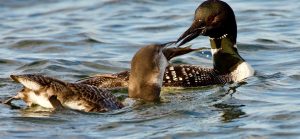
When necessary, our volunteers place loon nesting buoys and warning signs in areas where nests or young chicks are vulnerable to boat traffic. Much of the information we track is gathered through monthly loon watcher surveys which are coordinated by Diane Power. We also write a column reporting on our progress and emerging challenges for each newsletter.
We welcome your interest and involvement. Our contact information is below. Please check this site frequently as we will post links to useful information regarding our loons.
Erin Adams erinadams62@gmail.com
Sheryl Ducharme sducharme1@aol.com
- Click this link to learn some facts about loons (and what the loons are saying): Loon calls
- The Common Loon has been named the Bird of the year for 2025
(This is a video regarding loons in Maine, you may skip the ad)
- What to do if you see a distressed loon
- Boating practices near loons (from the New Hampshire loon organization)
- The Loon Project blog